| ||||||
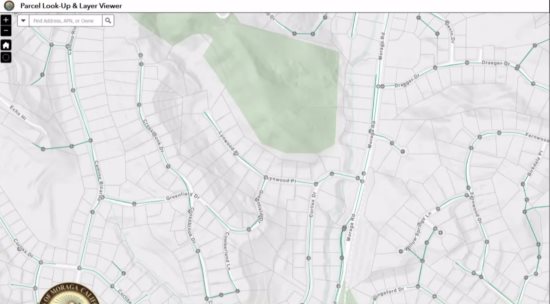
During a status update of the three-year project at the Sept. 11 town council meeting, Planning Director Derek Farmer was excited to preview for council members some of the GIS capabilities.
Town Manager Cynthia Battenberg explained that the project was funded due to the $55,000 savings in salary due to the vacancy of an assistant planner position.
Placeworks, the same firm that is at the helm of the Moraga Center Specific Plan meetings and design scenarios, is behind setting up Moraga's GIS.
The project's goal is to provide easily accessible property and infrastructure information to town staff and the community while building on layers from public works and the planning departments.
Some of the data layers currently available through the system are: land parcels; zoning; general plan use, emergency routes; roads; traffic collisions, scenic corridors; parks and trails; ADA ramps; earthquake faults; landslides; wildfire threats and more.
The GIS provides for the layering of information, which will help the town make decisions, increasing efficiency and transparency, because much of the information will be easily available to residents. However, for security and privacy reasons, not every aspect will be available to the public.
Advantages to town staff and the public are the web-based tools to access the town's data, such as property information, map printing, overlay data, ability to place comments and run queries, conduct analysis and export data.
Residents will be able to access the GIS by going to the town's website home page and clicking onto the GIS/Mapping Tool located under Quick Links.
While the project has reached the halfway mark, yet to come is staff training for utilization purposes, the planning projects public application, the public works public application and a development of a maintenance plan to ensure data and applications are kept up to date.
Council Member Steve Woehleke was concerned about cybercrimes and how the system will be protected from either being erased or from unauthorized access. It was explained that the system is housed on Esri, an international supplier of GIS software widely recognized for keeping their sites secure.
Reach the reporter at:
